Planix R1 and I-Guide
The Planix R1: Professional Surveying Without the Subscription Trap
In a world where most 360° reality capture involves "renting" your own data back from a cloud provider, the Planix R1stands out by being remarkably sensible. It is a straightforward tool for professionals who prefer to own their work, end-to-end.
By mounting a Ricoh Theta atop a high-precision horizontal LiDAR unit, the R1 does more than just take pretty pictures. It captures the physical geometry of a space in real-time, allowing you to generate RICS-compliant area measurements and accurate building layouts without the typical "SaaS tax."
The "Owner-Operator" Advantage
- Complete Data Sovereignty: You aren't locked into a proprietary ecosystem. You can download your raw images, CAD-ready data, and building layouts directly. Your data stays yours, even if you never log in again.
- Precision by Design: The horizontal LiDAR provides the structural "truth" of a building, while the Theta provides the visual context. This combination is specifically engineered for creating high-accuracy floor plans that meet strict professional standards.
- Rich Documentation: Beyond the geometry, you can integrate tags and detailed layout drawings directly into your project files, ensuring that the "when, what, and where" of a site visit or your data are never lost.
Experience the Workflow
If you want to see what this hardware is actually capable of in a professional environment, you can view examples of my recent survey work here: examples below
Visual Knowledge Management Applications
Facilties and Asset Management

While any hobbyist with a smartphone can technically "capture a map," the Planix R1 is built for the professional who needs a digital twin that actually functions as a long-term asset. For asset management, the value isn't in the picture; it’s in the data's permanence and precision.
- Permanent Data Sovereignty: You own the raw LiDAR and 360° files outright, ensuring your asset records remain accessible decades from now without being held hostage by a SaaS subscription.
- Survey-Grade Accuracy: By capturing RICS-compliant geometry, you generate "source of truth" floor plans that can be used for precise area calculations, lease agreements, and tax valuations.
- Dynamic Asset Tagging: Embed maintenance records, serial numbers, and warranty data directly into the spatial layout, creating a visual, searchable inventory of every HVAC unit and fire exit.
- BIM-Ready Integration: The ability to export native DWG and RVT files means your site capture flows directly into facility management software without tedious manual tracing.
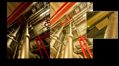
- Audit-Proof Documentation: High-resolution 60MP imagery combined with LiDAR provides an indisputable "point-in-time" record of a property’s condition, essential for insurance and handover.
Martyn's Law
The Planix R1 allows you to move beyond simple "virtual tours" and create a professional, audit-ready framework for Martyn’s Law (the Terrorism Protection of Premises Act 2025).
Because the R1 uses horizontal LiDAR to create a precise "source of truth," your compliance isn't just a paper exercise—it's built into a digital twin that you own and control
.
Martyn’s Law Compliance & Preparedness
- RICS-Compliant Precision: Generate high-accuracy, survey-grade floor plans required for mandatory Standard Tier (200+ capacity) and Enhanced Tier (800+ capacity) preparedness plans.
- Strategic Asset Tagging: Use the tagging system to digitally mark the exact location of critical safety assets, including PAcT (Public Access Trauma) kits, AEDs, and emergency shut-off valves.
- Vulnerability Mapping: Identify and document "blind spots," lockdown points, and entry-control zones with 60MP visual clarity, providing a clear map for security risk assessments.
- Immersive Staff Training: Conduct virtual "risk-free" walk-throughs to train employees on evacuation, invacuation, and lockdown procedures without disrupting site operations.
- Documented Audit Trail: Maintain a time-stamped, unalterable visual record of your premises to prove to regulators (SIA) and insurers that your safety protocols are active and verified.
- Secure Data Sovereignty: Avoid the risks of third-party cloud storage by owning your data locally; share sensitive structural layouts only with authorised emergency services and local authorities.
PFI Handback
Inspection and Condition
With hundreds of PFI contracts nearing their expiry, the "Handback" process has become a high-stakes transition. The Planix R1 serves as your ultimate verification tool, ensuring that the public sector receives assets in the exact condition promised, while private partners can prove their maintenance obligations have been met.
Here is how the R1 specifically supports the PFI-Handback process:
PFI Handback: Verification & Dispute Resolution
- Definitive Asset Condition Records: Capture a comprehensive, 60MP "visual baseline" of every room and corridor, providing indisputable evidence of the asset's condition at the point of handover.
- RICS-Compliant Area Validation: Use the horizontal LiDAR to verify that the physical floor area and room configurations align exactly with the original Project Agreement and any subsequent variations.
- Audit-Ready Compliance Data: Unlike generic 360° tours, the R1 allows you to download and own the raw data, creating a permanent, non-subscription record that can be archived for legal and financial close-out.
- Maintenance & Lifecycle Proof: Use digital tags to link O&M manuals, service history, and warranty documents directly to the physical assets (boilers, AHUs, fire doors), proving that lifecycle requirements have been fulfilled.
- Seamless Information Transfer: Export survey-grade DWG and RVT files to ensure that the incoming Facility Management team has accurate, "as-built" data from Day 1, preventing service disruption.
- Dispute Mitigation: By providing a "source of truth" that combines measurable LiDAR geometry with visual context, you significantly reduce the risk of costly dilapidation claims and "last-minute fix" arguments.
Inspection and Condition
Inspection and Condition
Inspection and Condition
When it comes to long-term asset health, a single snapshot is just a moment in time. The real power of the Planix R1 lies in Temporal Comparison—the ability to overlay scans from different years to pinpoint exactly how a building is ageing, shifting, or degrading.
By using RICS-compliant LiDAR, you aren't just looking at pictures; you are measuring structural change over time.
Systematic Inspection & Condition Monitoring
- Visual Time-Lapse Auditing: By capturing the same "Control Points" annually, you can flip between 60MP scans to spot subtle changes in masonry, damp penetration, or wear-and-tear that a manual walk-through might miss.
- Structural Displacement Tracking: Use the horizontal LiDAR to monitor "drift" or warping in partitions and structural elements. Because the data is yours to keep, you can compare a 2026 scan to a 2030 scan with centimetre-level context.
- Predictive Maintenance Tagging: Move beyond reactive fixes. By tagging assets with their "Last Inspected" date and current condition grade, you create a visual heatmap of which plant rooms or building wings require the most budget in the coming cycle.
- Lifecycle Evidence: Avoid "he-said, she-said" disputes with contractors. Provide indisputable, time-stamped proof of an asset's condition before and after a maintenance contract, ensuring you only pay for the results you receive.
- The "No-Subscription" Archive: Since you own the raw data, your historical records aren't trapped behind a monthly fee. You can build a 25-year structural history of a building that remains accessible even if software platforms change.
Tacit Twins
Inspection and Condition
Disabilty Access Mapping
The "Silver Tsunami" describes the massive wave of veteran surveyors, engineers, and facility managers reaching retirement age. When they leave, they take decades of tacit knowledge—the unwritten "know-how" and professional intuition—with them.
The Planix R1 and Ricoh Theta X allow you to "harvest" this expertise, turning a person's life experience into a permanent, digital Tacit Twin.
Harvesting Knowledge: The Tacit Twin Strategy
- Visualising the Unwritten: Use the 60MP imagery of the Ricoh Theta X to walk a site with your senior staff before they retire. Have them "tag" specific assets with the subtle details never found in a manual—like which valve tends to stick or the specific sound a healthy pump should make.
- Contextual Wisdom Capture: Unlike a flat document, a 3D Tacit Twin allows a veteran to record voice notes or video clips directly at the location of an asset. This preserves the "why" and "how" behind their decisions in the exact physical context where they happen.
- Bridge the Skills Gap: Use these annotated virtual tours to onboard the next generation. New hires can explore the building through the eyes of a 40-year veteran, learning the "tricks of the trade" in a risk-free, immersive environment.
- Permanent Institutional Memory: Because you own the R1 data, this knowledge doesn't disappear when a subscription ends or an employee walks out the door. You are building a permanent, searchable library of your organisation’s collective intelligence.
- Millimetre-Accurate Handoffs: The horizontal LiDAR provides the "structural truth" that backs up the veteran's intuition. When a senior engineer says a floor is unlevel or a wall is prone to damp, the R1 provides the empirical data to prove it.
- The "Digital Mentor" Effect: By integrating these tags into your building layouts, you create a "Digital Mentor" that stays on-site 24/7, guiding junior staff through complex inspections using the captured wisdom of those who came before them.
Disabilty Access Mapping
Inspection and Condition
Disabilty Access Mapping
The Planix R1 and Ricoh Theta X provide a transformative approach to accessibility auditing for high-traffic environments like university campuses, public buildings, and transport hubs. By capturing survey-grade measurements and immersive visuals, you can move beyond a "tick-box" exercise to a dynamic, RICS-compliant accessibility map.
Accessible Mapping for Universities, Public Buildings, and Transport Hubs
- Millimeter-Accurate Barrier Detection: Use the R1’s horizontal LiDAR to verify ramp gradients, door widths, and counter heights against Equality Act 2010 and Part M Building Regulations, ensuring every measurement is an empirical "source of truth."
- Immersive Wayfinding for Students & Passengers: Provide high-resolution 60MP virtual walkthroughs that allow users with mobility or sensory impairments to "pre-travel" their route, identifying step-free access and quiet zones before they arrive.
- Digital Access Tagging: Embed interactive tags at key locations—such as hearing loops, accessible toilets (with RADAR key info), and assistance points—giving users instant, on-site information via their mobile devices.
- Audit-Ready Compliance Exports: Since you own the data, you can export precise DWG or PDF floor plans to demonstrate "reasonable adjustments" to regulators, insurers, or estate planners without recurring software fees.
- Multi-Site Estate Management: Rapidly scan entire campuses or transport networks; the R1’s speed allows you to map complex hubs in minutes, creating a centralized, digital inventory of accessibility assets across your entire portfolio.
- Inclusive Design Collaboration: Share secure, private links with accessibility consultants and disability groups to conduct remote audits, ensuring that diverse "lived experience" feedback is integrated directly into your facility planning.
Insurance
Insurance
Insurance
Precision Claims: Why Insurance Professionals Demand iGuide & Planix R1
In the aftermath of a loss—whether fire, flood, or structural failure—the speed and accuracy of the settlement depend entirely on the quality of the initial data. Traditional tape measures and static photos leave too much to interpretation, leading to disputed claims and delayed recovery.
RICHpix 360 Ltd leverages the Planix R1 and the iGuide ecosystem to provide a comprehensive "Digital Forensic Wrap" for any insured asset.
The Problem: The High Cost of "Good Enough"
- Scope Creep: Inaccurate floor plans lead to underestimating material costs.
- Liability Gaps: Missing visual evidence of pre-existing conditions or post-loss mitigation.
- Administrative Bloat: Adjusters spending hours manually drafting sketches from rough field notes.
The Solution: The iGuide Advantage
The Planix R1 isn't just a camera; it is a rapid-capture LiDAR and 360° imaging powerhouse. When we deploy this technology for insurance purposes, we deliver:
- Guaranteed Square Footage: iGuide’s uncertainty level is typically less than 0.5%, providing the most accurate floor plans in the industry for Xactimate® or Symbility® integration.
- HDR Forensic Detail: Our Planix R1 workflow captures every corner in high dynamic range. Whether it’s smoke damage on a ceiling or water ingress behind a baseboard, the evidence is captured in 360°—total site immersion without the need for a return visit.
- Instant Virtual Estimating: Adjusters can "walk the loss" from their desk. They can measure any distance within the image, ensuring that every radiator, window, and light fixture is accounted for in the initial estimate.
Key Applications for the Insurance Sector
1. Pre-Loss Risk Documentation
The best way to settle a claim is to have proof of what existed before. We provide high-fidelity "As-Insured" twins for high-value estates and commercial assets. This creates a baseline that makes "Betterment" disputes a thing of the past.
2. Post-Loss Forensic Capture
Within hours of a disaster, we capture the "Visual Truth." This documentation is crucial for subrogation, structural engineering reviews, and policyholder transparency.
3. The "Golden Thread" for Compliance
For complex commercial claims, we provide a time-stamped, unalterable record of the site. This satisfies the "Golden Thread" of information required by modern underwriters and regional regulators in the EMEA.
Why RICHPiX for Insurance?
Unlike "consumer-grade" virtual tours, our iGuide outputs are:
- Xactimate® Compatible: ESX files ready for immediate import into your estimating software.
- Data Sovereign: As with all RICHpix services, we prioritise Secure Data Management. Your sensitive claim data isn't just floating in a public cloud; it is managed with the rigour required for legal and forensic scrutiny.
- HDR Quality: We ensure lighting is optimised so that serial numbers on equipment and fine details of damage are actually readable—not just a blurry "representation."
Who Needs This?
- Loss Adjusters & Surveyors: Reduce site time by 70% while increasing data accuracy.
- Restoration Contractors: Get estimates approved faster with indisputable visual backup.
- Risk Managers: Lower premiums by providing underwriters with high-fidelity asset data.
- Policyholders: Ensure you are compensated for the actual footprint and finish of your property.
